A massive winter storm has stopped
most Great Lakes vessel traffic
10 a.m. SATURDAY UPDATE: Some vessels were on the move Saturday morning as it appeared the worst of the storm had passed.
ORIGINAL REPORT: With high winds Friday night and into Saturday, most Great Lakes vessels prudently headed to anchor or remained in port. Forecasters say northeast winds will blow 30 to 40 knots with gusts
up to 55 knots with waves 18 to 23 feet expected.
NWS meteorologists issued a Storm Warning for Lake Superior beginning 1 p.m. on Friday, Jan.
11, until 7 p.m. Saturday, Jan. 12 as the looming storm – expected to rapidly intensify into a
dangerous blizzard – moves in over the weekend.
Heeding the warnings, Edgar B. Speer, Great Republic and H. Lee White were moored at Duluth.
Philip R. Clarke and Walter J. McCarthy Jr. were at Two Harbors, with Indiana Harbor hugging
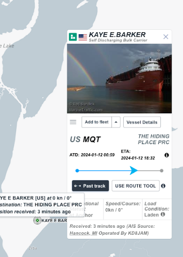
the shoreline headed there. John J. Boland was in Thunder Bay. Kaye E. Barker snuggled up
close to the shore in the lee of the Keweenaw Peninsula. Edwin H. Gott was stopped behind the
Apostle Islands.
The lower St. Marys River above DeTour hosted Harvest Spirit, James R. Barker, Herbert C.
Jackson, American Integrity, Lee A. Tregurtha and Dirk S. VanEnkevort/Erie Trader Friday night.
Olive L. Moore/Menominee, Samuel De Champlain/Innovation, Stewart J. Cort and Burns
Harbor were anchored off Brevort, MI. Arthur M. Anderson pulled into the bay off Petoskey,
MI.
Algoma Intrepid, Defiance/Ashtabula and American Mariner were stopped above Port
Huron/Sarnia. On the hook off Sandusky/Huron, OH, were Algoma Niagara, Mark W. Barker,
American Century, Hon. James L. Oberstar and Manitowoc.
The National Weather Service said Lake Superior, Lake Huron, Lake Michigan, Lake St. Clair and
down into Lake Erie will be roiling with dangerous waves and winds that have the potential to
overturn ships and could even lead to lakeshore flooding.
Experts sent an urgent warning for sailors to remain at port or secure their vessel for severe
conditions as the storm moves through.
More dangerous is a Heavy Freezing Spray Warning also in effect for central, eastern and
western Lake Superior the same timeframe that will see freezing spray at a rate of 2 cm per
hour or greater expected and may rapidly accumulate on vessels.
Operating a vessel in heavy freezing spray is hazardous, the NWS cautioned. Freezing spray
may render mechanical and electronic components inoperative. Rapid ice accretion on decks
and superstructures may result in a catastrophic loss of stability. Very strong winds will cause
hazardous waves which could capsize or damage vessels and reduce visibility.
The northern waters of Lake Huron from 5 NM east of Mackinac Bridge to Presque Isle Lt
beyond 5 NM off shore and from Presque Isle Light to Sturgeon Point beyond 5 NM off shore
under a Storm Warning that remains in effect from Friday morning until Saturday evening with
forecasted sustained winds up to 44 knots from the northeast with gusts up to 50 knots.
The National Weather Service said Lake Superior, Lake Huron, Lake Michigan, Lake St. Clair and
down into Lake Erie will be roiling with dangerous waves and winds that have the potential to
overturn ships and could even lead to lakeshore flooding.
The northern waters of Lake Huron from 5 NM east of Mackinac Bridge to Presque Isle Lt
beyond 5 NM off shore and from Presque Isle Light to Sturgeon Point beyond 5 NM off shore
under a Storm Warning that remains in effect from Friday morning until Saturday evening with
forecasted sustained winds up to 44 knots from the northeast with gusts up to 50 knots.
The largest significant waves will be 20 feet with a potential maximum wave height of 29 feet
expected around midnight on Saturday.
Southern Lake Huron – from Outer Saginaw Bay SW of Alabaster to Port Austin MI to Inner
Saginaw Bay to include Port Austin, Harbor Beach, Port Sanilac, Port Huron – is all under a Gale
Warning. Forecasters say hazardous conditions will include sustained winds up to 35 knots from
the southwest with gusts up to 46 knots. The largest significant waves will be 14 feet with a
potential maximum wave height of 20 feet expected around 9 p.m. Friday.
On the west side, the northern half of Lake Michigan, north of a line from Two Rivers, WI, to
Manistee, MI, is under a Gale Warning which is expected to upgrade to a Storm Warning from
Friday morning into Saturday morning.
For the first Gale Warning, east winds 20 to 30 kt with gusts up to 40 kt and waves 6 to 9 feet
expected, the NWS said. For the Storm Warning, northeast winds 30 to 40 kt with gusts up to
50 kt and waves 12 to 17 ft expected. For the second Gale Warning, north to northwest winds
25 to 35 kt with gusts up to 45 kt and waves 11 to 16 ft expected.
The National Oceanic and Atmospheric Administration (NOAA) said waves will be so impressive,
they could lead to lakeshore flooding along Lake Michigan's southern shores, to include Benton
Harbor, St. Joseph, Lakeside, New Buffalo and more.
On Lake Erie, mariners from the Islands to Conneaut, Ohio can expect southwest winds
between 40 to 50 knots with gusts up to 60 knots and waves 13 to 18 feet possible with a Gale
Watch in effect from Friday afternoon through Sunday morning.
Southeast winds Friday evening become southwest Friday night, the NWS said of conditions
of Lake Erie. The strongest winds are expected on Saturday. Abnormally low water levels are
possible in the western basin of Lake Erie.
Strong southwesterly winds will cause water levels to quickly drop across the western basin of
Lake Erie, the NWS said. The critical mark for safe navigation at Toledo is 6 inches above low
water datum. The current projection is for water levels to fall 2 to 4 feet below the critical
mark.
Mariners were urged to navigate shallow waters with extreme caution.
WWJ, Boatnerd reports
In St. Joughnuts, dockside doughnut
deliveries welcome freighters
This story is part of Mornings in Michigan, our series about morning rituals from across our
state.
Another Great Lakes shipping season comes to an end on Monday when the Soo Locks close for
annual maintenance. Massive freight ships are icons of the Great Lakes and they're woven into
the identities of Great Lakes port towns.
In one town on Lake Michigan, folks show their appreciation by greeting almost every big ship
and crew that comes to harbor with a sweet treat, free of charge.
That’s how St. Joseph, Michigan has earned the nickname St. Joughnuts by sailors in the know.
The first thing you need to know about St. Joseph is it’s a boat-watching haven. It’s located on
the shoreline of Lake Michigan south of Muskegon. The St. Joseph River runs between St.
Joseph and neighboring Benton Harbor near downtown. When freighters hundreds of feet long
and dozens of feet tall come through, it’s a tight fit, so the views are great.
“One thing I like about our port is just how small, and I would say, intimate it is,” said St. Joseph
harbormaster Mike Moran. “You’re up close to the freighters. No matter where they’re at,
you’re up close and can see them very easily.”
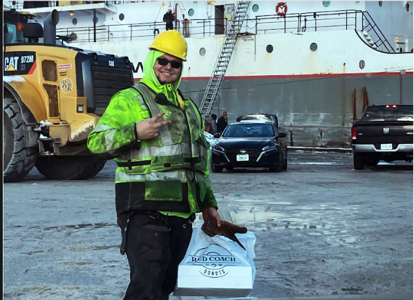
On April 2, 2021, Moran started a new tradition. When a big boat comes to town, he hand-
delivers fresh, free doughnuts to the crew.
Read more and view photos here: https://www.michiganpublic.org/community/2024-01-
12/mornings-in-michigan-in-st-joughnuts-dockside-doughnut-deliveries-welcome-
freighters?fbclid=IwAR1Y7pI52IWB8U35PgrlH1xICKFcuW4_j-DvBLlpJnqxs2JcpQjWxt74F_o
Winter lay-up list is now active
You can monitor our annual lay-up listing page here: https://boatnerd3.jasonbowlerdesign.com/winter-lay-up-list-2023-2024/
The page will be updated throughout the winter. Please send lay-up reports to news@boatnerd.net.